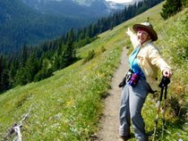
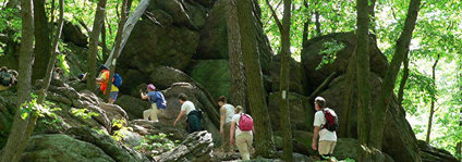
Scroll Down For Hike Descriptions
- SPECIAL NOTICE
As of 03/06/24
And remember, No Hike Leader, No Hike. So please, look over the schedule and if there are any hike(s) you feel comfortable leading, contact me (stevesee@ymail.com) and I'll get you on the schedule.
Ramblers Hike Schedule
(Q2– 2024)
(April, May June)
**NOTE**
We have upped the limit of hikers to 16 for each hike (including leader, also leader may reduce this limit due to circumstances). If you would like to go, you MUST contact the hike leader via email by Sunday at 2 p.m. before the Monday scheduled hike AND NO SOONER THAN THE HIKE ANOUNCEMENT VIA THE RAMBLERGRAM (The Ramblergram will now come out on Thursdays around 8AM). You will get a confirmation that you are one of the people hiking.
Click Here to Download a Copy of Q2 -2024 Schedule
Leaders - Click Here to Download a Copy of the Rambler's Sign-In Sheet
or - Click Here to Download a Copy of the Hike Leader Responsibilities and Guidelines
4/01 (A) Dosewallips Cascades (Pete Alexander - Leader)
(B) Leader’s Choice (Jamileh Pott - Leader)
4/08 (A) Fort Worden Special (Marilyn Hunt - Leader)
(B) Fort Worden (Ambler) (Frankie Andrews - Leader)
4/15 (A) Port Gamble (Richard Serkes – Leader)
(B) Lake Angeles (Rosie Tomlin – Leader)
4/22 (A) Storm King (Doug Smith – Leader)
(B) Lena Lake (MaryJane Mitchell – Leader)
4/29 (A) Camp Jolley (Steve See – Leader)
(B) Leader’s Choice (George Moyer – Leader)
5/06 (A) Tubal Cain to Buckhorn Pass (Andrea Fry – Leader)
(Ambler Option-Tubal Cain to Copper Creek)
(B) Lovers Lane (Frankie Andrews – Leader)
5/13 (A) Big Hump/Little Hump (Lori Reale – Leader)
Early Start – 8AM
(B) Murhut Falls/Little Hump (Ambler) (TBD - Leader)
Late Start – 9AM
5/20 (A) Dungeness River – Shelter to Shelter Bev Atkinson - Leader)
(B) Mink Lake (MaryJane Mitchel – Leader)
5/27 (A) Miller Peninsula – East (Cindy Enstrom - Leader)
(B) Dungeness Trails (Gary Huff - Leader)
6/03 (A) Lower Dungeness (Richard Serkes - Leader)
(B) Joyce Piedmont Rd – East (Soonja Spees - Leader)
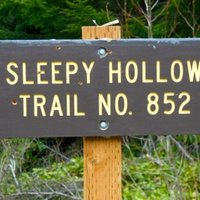
6/10 (A) Sleepy Hollow/Mt Zion (Marilyn Snook – Leader)
(B) Sleepy Hollow/Riverside Ramble (Ambler) (Frankie Andrews - Leader)
Late Start – 9AM
6/17 (A) Tunnel Creek to 50/50 Pass (Burt Peterson - Leader)
Early Start – 8AM
(B Tunnel Creek to Shelter (Ambler) (Peg Phillips - Leader)
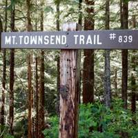
6/24 (A) Mt Townsend (Burt Peterson - Leader)
(B) Leader’s Choice (Ambler) (TBD - Leader)
-----------------------------------------------------------------------------------------------------
04/29/24 Camp Jolley
Hike 'A': Camp Jolley
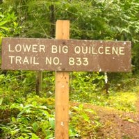
Many Ramblers will be familiar with the first part of this hike since it begins in the parking lot for the Lower Big Quilcene Trail (FS #833). This is the trail that takes hikers to Bark Shanty and then just beyond that to the junction with the Notch Pass Trail. But rather than turn off of the Lower Big Quilcene Trail we’ll stay on it on our way to Camp Jolley.
The Big Quilcene River which was close enough to hear but not really see now becomes our constant companion on the way to Camp Jolley. At times we’ll be just a few feet above the level of the river and at times we’ll be at river level. Camp Jolley itself is on the river providing a wonderful lunch spot before returning to the cars.
This is a relatively flat trail overall but a new 'bypass trail' takes us up and away from the river for a short distance and adds a couple of hundred feet of elevation gain to the hike. This was needed because a section of old trail that has become dangerous due to slides and washouts. The trailhead is at 1,440’ above sea level and Camp Jolley is just 1,990’ above sea level.
Date: 04/29/24
Distance: 10.2 Miles
Elevation Gain: 1,500 Feet
Hike Leader: Steve See
----------------------
If you are interested in this hike, email the hike leader by 2 pm on the Sunday before the hike AND NO SOONER THAN THE HIKE ANOUNCEMENT VIA THE RAMBLERGRAM. You will get a confirmation that you are on the list of hikers.
As always, our time and place of meeting are:
The public parking lot on Sequim Avenue (east side) just north of Washington.
We will leave at 8:30am. Please arrive about 10 minutes earlier for announcements and car assignments. The reimbursement for the drivers will be $5 from Sequim. Drivers may require masks.
If you have any questions or need additional information about the hike, please contact the Hike Leaders as early as possible.
04/29/24 Leader's Choice
Hike 'B': Leader's Choice
Date: 04/29/24
Distance: ? Miles
Elevation Gain: ? Feet
Hike Leader: George Moyer
----------------------
If you are interested in this hike, email the hike leader by 2 pm on the Sunday before the hike AND NO SOONER THAN THE HIKE ANOUNCEMENT VIA THE RAMBLERGRAM. You will get a confirmation that you are on the list of hikers.
As always, our time and place of meeting are:
The public parking lot on Sequim Avenue (east side) just north of Washington.
We will leave at 8:30am. Please arrive about 10 minutes earlier for announcements and car assignments. The reimbursement for the drivers will be $? from Sequim. Drivers may require masks.
If you have any questions or need additional information about the hike, please contact the Hike Leaders as early as possible.
05/06/24 Tubal Cain
Hike 'A': Tubal Cain to Copper Creek
This is one of the “rhody hikes” on the peninsula meaning that the trail is lined with rhododendron plants almost all the way from the trailhead to Copper Creek. When in season the visual effect and the fragrance is amazing.
This out-and-back hike takes us on a mild grade past both the Tull Canyon trailhead and the abandoned Tubal Cain Mine across Copper Creek to the campground. After lunch at the campground, we’ll return to the cars.
Date: 05/06/24
Distance: 8 Miles
Elevation Gain: 1,260 Feet
Hike Leader: Andrea Fry
----------------------
If you are interested in this hike, email the hike leader by 2 pm on the Sunday before the hike AND NO SOONER THAN THE HIKE ANOUNCEMENT VIA THE RAMBLERGRAM. You will get a confirmation that you are on the list of hikers.
As always, our time and place of meeting are:
The public parking lot on Sequim Avenue (east side) just north of Washington.
We will leave at 8:30am. Please arrive about 10 minutes earlier for announcements and car assignments. The reimbursement for the drivers will be $5 from Sequim. Drivers may require masks.
If you have any questions or need additional information about the hike, please contact the Hike Leaders as early as possible.
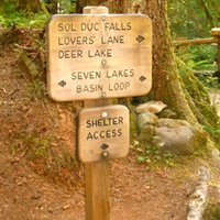
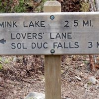
05/06/24 Lover's Lane
Hike 'B': Lover's Lane
Lovers Lane Trail is a 6.8 mile loop trail located in the Sol Duc Valley that features beautiful wildflowers and is rated as moderate. We’ll leave the parking lot of the Sol Duc Resort and hike south to the falls. After that we’ll go back to the resort hiking the other side of the river. Although the hike after the falls can entail some road walking there are paths in the woods which we will use instead.
Date: 05/06/24
Distance: 6.8 Miles
Elevation Gain: Minimal
Hike Leader: Frankie Andrews
----------------------
If you are interested in this hike, email the hike leader by 2 pm on the Sunday before the hike AND NO SOONER THAN THE HIKE ANOUNCEMENT VIA THE RAMBLERGRAM. You will get a confirmation that you are on the list of hikers.
As always, our time and place of meeting are:
The public parking lot on Sequim Avenue (east side) just north of Washington.
We will leave at 8:30am. Please arrive about 10 minutes earlier for announcements and car assignments. The reimbursement for the drivers will be $7 from Sequim. Drivers may require masks.
If you have any questions or need additional information about the hike, please contact the Hike Leaders as early as possible.
05/13/24 Big Hump/Little Hump
Hike 'A': Big Hump/Little Hump Early Start - 8AM
The Big Hump/Little Hump Trail is actually the Duckabush Trail #803 but is better known as Big Hump/Little Hump. However, the name is misleading. From the trailhead you hike up and over the Little Hump, back down to the Duckabush River and walk along the river valley before ascending the Big Hump. So it seems that it ought to be called the Little Hump/Big Hump hike.
The trailhead begins at 479’ above sea level and climbs to the top of Little Hump which is at 948’ and 1.23 miles from the trailhead. That’s a 469’ elevation gain in a little more than a mile. After that the trail descends 250’ in 0.34 miles to an old logging railroad grade thought to have been built around 1900. After a relatively short walk along the abandoned railroad grade the trail joins the Duckabush River at approximately Mile 2. The short walk between the Humps increases our altitude by a mere 35’. Then at Mile 2.74 we leave the river and begin a steep grade that takes us up to Big Hump, a large rock outcropping overlooking the Duckabush River Valley. Once at Big Hump we’ll be at 1,763’ which is a 1,030’ gain in 1.53 miles.
After reaching Big Hump the trail climbs just a little more before it descends approximately 636’ in 1.14 miles to continue on to a picturesque campground by the Duckabush River. This is where we will have lunch before returning to the trailhead.
Date: 05/13/24
Distance Hiked: 11.9 miles
Total Elevation Gain: 2,639’
Hike Leader: Lori Reale
----------------------
If you are interested in this hike, email the hike leader by 2 pm on the Sunday before the hike AND NO SOONER THAN THE HIKE ANOUNCEMENT VIA THE RAMBLERGRAM. You will get a confirmation that you are on the list of hikers.
As always, our time and place of meeting are:
The public parking lot on Sequim Avenue (east side) just north of Washington.
We will leave at 8:30am. Please arrive about 10 minutes earlier for announcements and car assignments. The reimbursement for the drivers will be $7 from Sequim. Drivers may require masks.
If you have any questions or need additional information about the hike, please contact the Hike Leaders as early as possible.
05/13/24 Murhut Falls/Little Hump
Hike 'B': Murhut Falls/Little Hump Late Start - 9AM
This will be an 'Ambler' hike, so we'll start by checking out Murhut Falls before we begin the Little Hump hike. This short 1.6-mile round trip hike begins farther down Duckabush Rd a couple of miles. We'll drive there and check out the falls first.
Here's a short description from the Washington Trails Association:
The well-maintained Murhut Falls Trail begins with a gradual ascent, then flattens out before the final steep ascent to your destination at 1,050 feet. This is Pacific Rhododendron country, so if you hike this trail in spring, you’ll find yourself surrounded by pink bursts of bloom splashed against the surrounding green forest. You may or may not notice that the trail was converted from an old logging road, which accounts for the easy, smooth tread. The roar of falling water greets you on the final stretch of trail as you descend into the hidden ravine that shelters the tiered falls.
After our little jaunt to the falls, we'll return to the cars and drive back to the parking lot for the Duckabush Trail #803 and head out towards Little Hump.
The trailhead begins at 479’ above sea level and climbs to the top of Little Hump which is at 948’ and 1.23 miles from the trailhead. That’s a 469’ elevation gain in a little more than a mile. We can return to the cars from there or if the group feels like going a little further, the trail descends 250’ in 0.34 miles to an old logging railroad grade thought to have been built around 1900. After a relatively short walk along the abandoned railroad grade the trail joins the Duckabush River at approximately Mile 2. The short walk between the Humps increases our altitude by a mere 35’. After that, it's a steep grade up to Big Hump which we will not do. Lunch can be anywhere along the route.
Date: 05/13/24
Distance Hiked: Up to 6 miles
Total Elevation Gain: Up to 1,000’
Hike Leader: TBD
----------------------
If you are interested in this hike, email the hike leader by 2 pm on the Sunday before the hike AND NO SOONER THAN THE HIKE ANOUNCEMENT VIA THE RAMBLERGRAM. You will get a confirmation that you are on the list of hikers.
As always, our time and place of meeting are:
The public parking lot on Sequim Avenue (east side) just north of Washington.
We will leave at 8:30am. Please arrive about 10 minutes earlier for announcements and car assignments. The reimbursement for the drivers will be $7 from Sequim. Drivers may require masks.
If you have any questions or need additional information about the hike, please contact the Hike Leaders as early as possible.
05/20/24 Dungeness River-Shelter to Shelter
Hike 'A': Dungeness River - Shelter to Shelter
This Monday the Ramblers will do something a little different. We'll be going to a familiar place but changing it up a bit. We'll start at the Upper Dungeness parking lot and first go down the Lower Dungeness Trail. This is a beautiful section of old growth forest heading down river. We'll travel 1.3 miles to a washout that's passable and has been improved. Continuing will lead us to the shelter and the lower trailhead. We'll stop at the shelter for a quick break then turn around and head back to the parking lot. We will then follow the Upper Dungeness Trail to Camp Handy as our hopeful lunch destination. We will then return to the cars. It's a 6.8 mile round trip to Camp Handy so together we'll have around a 9.5 mile day with an elevation total of around 1,250 feet.
Date: 05/24/24
Distance Hiked: 9.5 miles
Total Elevation Gain: 1,250’
Hike Leader: Bev Atkinson
----------------------
If you are interested in this hike, email the hike leader by 2 pm on the Sunday before the hike AND NO SOONER THAN THE HIKE ANOUNCEMENT VIA THE RAMBLERGRAM. You will get a confirmation that you are on the list of hikers.
As always, our time and place of meeting are:
The public parking lot on Sequim Avenue (east side) just north of Washington.
We will leave at 8:30am. Please arrive about 10 minutes earlier for announcements and car assignments. The reimbursement for the drivers will be $5 from Sequim. Drivers may require masks.
If you have any questions or need additional information about the hike, please contact the Hike Leaders as early as possible.
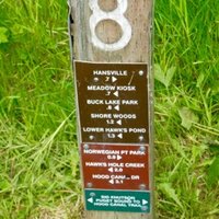
05/20/24 Mink Lake
Hike 'B': Mink Lake
The hike to Mink Lake begins at the Sol Duc Resort parking lot. The trail, labeled a “leisurely hike,” winds south through second-growth timber to a lovely small backcountry lake surrounded by meadows and huckleberries. Robert Wood says Mink Lake, choked with vegetation, is an example of a lake destroying itself. The trail is rocky in places with an elevation gain of about 1,450 feet over 3.0 miles.
The group may want to take a short hike to the Sol Duc Waterfalls (0.8 miles) and/or an additional hike down Lovers Lane. Lovers Lane is a trail that parallels the Sol Duc River on the west side from the waterfalls to the Sol Duc Resort parking lot.
The Lovers Lane extension could add about 3.8 miles to the Mink Lake hike.
Date: 05/20/24
Distance Hiked: 6 - 10 miles
Total Elevation Gain: 1,650’
Hike Leader: MaryJane Mitchel
----------------------
If you are interested in this hike, email the hike leader by 2 pm on the Sunday before the hike AND NO SOONER THAN THE HIKE ANOUNCEMENT VIA THE RAMBLERGRAM. You will get a confirmation that you are on the list of hikers.
As always, our time and place of meeting are:
The public parking lot on Sequim Avenue (east side) just north of Washington.
We will leave at 8:30am. Please arrive about 10 minutes earlier for announcements and car assignments. The reimbursement for the drivers will be $7 from Sequim. Drivers may require masks.
If you have any questions or need additional information about the hike, please contact the Hike Leaders as early as possible.
05/27/24 Miller Peninsula - East
Hike 'A': Miller Peninsula - East
The Miller Peninsula just east of Sequim is a warren of trails designed for hiking, biking and horseback riding. This is now an official State Park so it now requires a Discover Pass. There have been some great improvements recently including a new large parking area off of Diamond Point Road and added signage on the trails to aid in navigation. The trails allow for a variety of route options including loops, out and backs, and also trails leading to the edge of the Strait of Juan de Fuca for views of Protection Island and beyond.
This time we'll be hiking the east side of the peninsula with our leader charting a route you're sure to enjoy.
----------------------
Date: 05/27/24
Distance Hiked: Approx. 9 Miles
Total Elevation Approx. 1,200’
Hike Leader: Cindy Enstrom
----------------------
If you are interested in this hike, email the hike leader by 2 pm on the Sunday before the hike AND NO SOONER THAN THE HIKE ANOUNCEMENT VIA THE RAMBLERGRAM. You will get a confirmation that you are on the list of hikers.
As always, our time and place of meeting are:
The public parking lot on Sequim Avenue (east side) just north of Washington.
We will leave at 8:30am. Please arrive about 10 minutes earlier for announcements and car assignments. The reimbursement for the drivers will be $2 from Sequim. Drivers may require masks.
If you have any questions or need additional information about the hike, please contact the Hike Leaders as early as possible.
05/27/24 Dungeness Trails
Hike 'B': Dungeness Trails
This is a fairly new multi-use non-motorized trail network. Dungeness Trails has been designed for mountain-bikers, walkers, runners, hikers, and horseback riders. Located just outside the city limits on River Road, Dungeness Trails was built by the Olympic Peninsula Bicycle Alliance (OPBA) in partnership with the Washington State Department of Natural Resources. The 10-15 miles of trails on 400 acres is well marked and maintained; they’re rated for level of difficulty for mountain bike riders—ranging from easy to very difficult. Our route and distance will be determined by the hike leader.
----------------------
Date: 05/27/24
Distance Hiked: Approx. 7-8 Miles
Total Elevation Approx. 300 -500 Feet
Hike Leader: Gary Huff
----------------------
If you are interested in this hike, email the hike leader by 2 pm on the Sunday before the hike AND NO SOONER THAN THE HIKE ANOUNCEMENT VIA THE RAMBLERGRAM. You will get a confirmation that you are on the list of hikers.
As always, our time and place of meeting are:
The public parking lot on Sequim Avenue (east side) just north of Washington.
We will leave at 8:30am. Please arrive about 10 minutes earlier for announcements and car assignments. The reimbursement for the drivers will be $1 from Sequim. Drivers may require masks.
If you have any questions or need additional information about the hike, please contact the Hike Leaders as early as possible.
Start Here

It Ain't The Yellow Brick Road